
This Tuesday had a nice ridge forecast, so I booked FVV with the intention of attempting 300 km. The cloud base was at 4000 ft with a stiff 20 kt north-westerly breeze, so strong thermals would be important. Rain and spread-out was likely to the north, so the Bury St. Edmunds - Edgehill triangle was decided on. Both the wind direction and a Hercules dropping parachutes at Wattisham, near Bury St. Edmunds, later in the day dictated an early start with Bury St. Edmunds as the first turn point.
The day looked good from quite early in the morning. When I got FVV out to the winch line the driver was in the winch and the gliders on the launch line had no pilots, so I moved up to take the first launch of the day. This was directly into a nice thermal, but I was greeted by a horrid electronic whistle when I got the wheel up. After thermalling up to 2000 ft I decided I couldn't stand the noise, lowered the wheel to get some peace and quiet, popped the airbrakes and landed.
Post landing discussions showed that the wheel-up warning system had been disconnected but not re-tested. We disconnected it some more and then I got a belly dolly from the hangar, put the glider on it and checked that wheel and airbrake operation were now silent. I returned the dolly to the hangar and took another winch launch an hour and a quarter after my first start.
Again I was quickly in lift and under a booming cloud street, so I sped up to stop myself climbing above 3100 ft and made a start 10 minutes after launch before climbing back under the street. Cloud base was about 4900 ft and I whistled downwind along the street toward Bury St. Edmunds between 3500 ft and cloudbase. The turn point at Bury St. Edmunds was well out into the blue to the north of my street, so I left it at 4500 ft to glide out, round the turn and back under the same street. It took just 33 minutes to cover the 57 km to Bury: try that by car! As I headed back to the street a big, blackish C130 Hercules flew past between me and my cloud at about my height, doubtless on his way to drop parachutes on Wattisham.
The street was still working well, so once under it and established in a climb from just under 2000 ft, I rode that thermal to 3500 ft and then set off upwind under the street, climbing all the way. After travelling some 12km I was back at 5000 ft and pushing the airspeed up to over 75 kts to keep from being sucked up into the cloud base. At Newmarket I moved onto a more northerly street and rode along that past Papworth Everard before moving back south to a third street at St. Neots and pushing on past Bedford, though the going was getting a bit slower as thin, high cirrus began to come in from the west. A good climb to 5000 ft just past Bedford saw me easily to Bozeat, but after this the thickening cirrus started to kill the lift so I was just above 3000 ft at the M1. The view ahead was a grey monochrome that became very dark to the north across Northampton. I moved south along the M1 in company with a Grob 109 motor glider which was much lower and soaring with its propeller feathered. I eventually found a rather dispirited cumulus that got me back up to 3000 after a low point of 2400 ft. A careful check of conditions toward Edgehill showed a distinct lack of useful clouds in that direction and a scan round showed that it was now raining quite hard over Northampton. By now the Grob was east of me and at cloud base, probably due to the use of its iron thermal. At this point I called it a day and headed for home.
Almost immediately I found some good air, climbing back to 4000 ft as I ran downwind under a final good bank of cumulus. From here I couldn't do better than descend steadily, crossing Bedford at 2800 ft and getting a small climb back to 3000 ft as I drifted toward Sandy. I was now in gliding range with 2000 ft in hand above circuit height and 18 km to run, so flew steadily home, dodging round the north of the Little Gransden air traffic zone and then dumping excess height with the airbrakes to slot into the circuit. The flight ended with a rather low final turn to keep clear of a Duo Discus that was ahead of me in the pattern, and a good landing. Thermal activity shut down at Gransden Lodge shortly after I landed and, with local rain showers threatening, we stopped flying for the day to pack the gliders back into the hangar.
 |
|
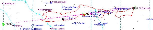
The route flown. |
 |
|
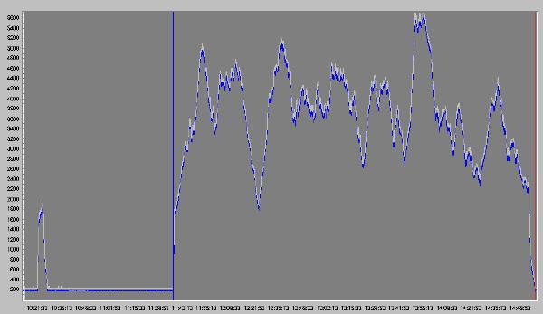
The barograph trace, showing both launches. |
After I'd uploaded the trace from my logger I measured it to calculate the unflown additional distance to and from Edgehill. I also used it to estimate ground speeds along the track to and from Edgehill and from that calculated the additional time that would have been required to complete the task: 1.22 hours. As my second launch was 1.26 hours after the first one, its possible that I could have completed the 300 km task if the wheel-up warning had been working properly. However, it would have been a very close run thing.
In summary this was an enjoyable flight in very varied conditions. The knowledge that I turned back without losing an opportunity of completing the task but still early enough to avoid landing out also gave me a lot of satisfaction.
| Time | Declared | Leg (km) | Flown | Leg (km) | |
| Takeoff | 12:37 | GRL | |||
| Start | 12:47 | GRL | GRL | ||
| Turn point 1 | 13:19 | BSE | 57.18 | BSE | 57.18 |
| Turn point 2 | 15:16 | EDG | 150.87 | OLN | 97.49 |
| End | 15:55 | GRL | 93.75 | GRL | 40.38 |
| Landed | 15:57 | GRL | |||
| Distance | 301.08 | 195.05 | |||
| Time | 3:08 | ||||
| Avg. speed | 62.25 kph |