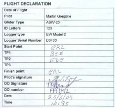
25th June, 2004 - success
This Friday was forecast to be a good ridge between two strong
depressions. The soundings showed no significant inversions which
promised strong lift to cloud base but had worryingly little gap
between the the wet and dry adiabatic curves, so I was a bit
pessimistic about the likely cloud base. This pessimism was
further reinforced by the first cumulus appearing at 09:00.
However, there was no initial spread out, so I rigged 123 for yet another attempt on 300 km.
The 20 kt north-north-westerly breeze meant that strong thermals
would be needed if they were not to be broken up by the wind. I
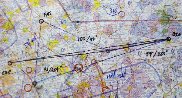
decided to tackle the Bury St. Edmunds - Edgehill triangle with
Bury St.Edmunds as the first turn point because I expected the
wind to moderate and swing south-west as the day progressed.
 |
|
My task is marked in black.
I'd also prepared a backup 316 km task: Bury St.
Edmunds/Bicester/Husbands Bosworth in case we got top cover
encroachment from the approaching depression to the west. This is
marked in blue. Places to avoid, from the NOTAMS, are marked in
red.
|
I got a decent cable launch to almost 1400 feet at around
midday. There was a good-looking cloud with a useful collection
of gliders under it to the south near Top Farm so I headed that
way, arriving in the lift at 1000 ft. This climb got me to cloud
base (3600 ft) over Wimpole Hall, so the westerly drift was
pretty strong. I headed back over Gransden Lodge, making a start
over the field at 12:27 and ran cloud streets over Cambridge and
Newmarket on a pretty direct route to Bury St. Edmunds. I stopped
to climb over the town just short of the turn point. This took me
from 2800 ft to 3900 while I drifted past the turn point, ready
to head round it and off to a useful cloud street off to the
north-west. This street took me round to the north of Cambridge.
At this point I changed streets and ended up under a non-working
cloud that eventually saw me at 800 feet, field picked, directly
over the canal midway between Soham and Earith. A bit of careful
scratching got me away again after 5-10 minutes and eventually to
3600 ft, all the while sitting over a long boat that was heading
east. I was able to measure my upward progress by the speed with
which the boat got smaller and the wind by the size of her bow
wave. Another change to a more southerly cloud street saw me due
north of Gransden Lodge with 1/3 of the task distance travelled.
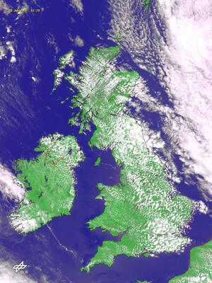
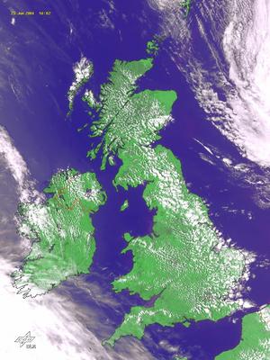
Analysing the log afterwards showed that it had taken half the
total flight time to get this far. However, as the following
satellite pictures show, despite the stiff breeze the day was
only getting better.
 |
 |
|
12:28 satellite
picture
|
17:02 satellite
picture
|
From here I stayed to the north of track to avoid getting
pushed south by the NNW breeze and having to struggle back north.
Another three cloud streets saw me past Sywell and round the
north side of Northampton, cruising mostly between 2500 and 4500
feet, running up the streets at 58 kts and jumping the gaps
between streets at 65-70 kts. As I came up to the M1 I checked my
map to see how close I was to the Daventry Control Area and,
realising that I was often travelling too high to get under it,
turned south for 10 km to get round its south-east corner. In the
event I almost cut it too fine, and was to spend the next 20 km
skirting the edge of the inner FL45 section rather than being
entirely clear of it. Fortunately, I didn't break the FL55
ceiling above me, never exceeding 5000 ft in this section. As I
came past Banbury, still on the north of the M40, I could see the
turn point at Edgehill and turned further south to head directly
to it, hopscotching along convenient clouds. I got round the turn
point at 3000 ft and straight under a good cloud immediately
south of the Shenstone Gliding Club: the turn point is their club
house. This cloud saw me back to 4500 ft and on to a succession
of clouds and short streets that gave a straight run back to the
north edge of Bedford. Here an excellent climb took me to 5200 ft
and a straight final glide home at 80 kts, ending with a 180
degree pass round the club house, which marked my finish point,
at 120 kts and 1300 ft.
 |
|
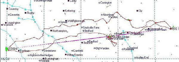
The route flown.
|
 |
|
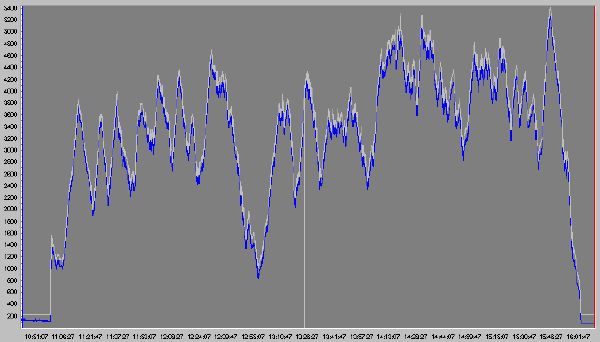
The barograph trace. Times are
GMT: all other times on this page are British Summer Time, one
hour later than GMT.
|
The average thermal strength for the day worked out at 4.3
kts. The strongest thermal I used gave a 6.9 kt average climb
rate. I'd pre-declared the flight and so I put in two badge
claims for the Gold Distance (300 km) and Diamond Goal Distance
(300 km as a predeclared triangle).
|
Time |
Declared |
Height (ft) |
Leg (km) |
| Takeoff |
11:58 |
GRL |
|
|
| Start |
12:27 |
GRL |
3530 |
|
| Turn point 1 |
13:13 |
BSE |
|
57.18 |
| Turn point 2 |
15:55 |
EDG |
|
150.87 |
| End |
16:58 |
GRL |
1660 |
93.75 |
| Landed |
17:03 |
GRL |
|
|
| Distance |
|
|
|
301.08 |
| Time |
|
|
|
4:31 |
| Avg. speed |
|
|
|
66.66 kph |
|
 |
On the 10th of July my FAI badge certificate was returned
confirming that I now have the distance leg of the Gold Badge and
the Goal Distance leg of the Diamond Badge.